Satellite companies curb access to Mideast imagery over concern it could be used “by adversarial actors”
In a marked shift, commercial satellite companies that provide open-source data used widely by many, including journalists and researchers, have restricted access to images showing Iran and the wider Middle East, including areas where there are U.S. military sites that have been targeted by Iran’s retaliatory fire.
Planet Labs, which regularly provides imagery used by news organizations including CBS News, said earlier this month that it was delaying the release of all new imagery of Iran, the Persian Gulf, U.S.-allied bases, and “existing conflict zones” for 14 days.
In a note to customers sent on March 9 and shared with CBS News by a spokesperson, Planet Labs said there were “genuine concerns of use of Planet data over Iran, as well as an extended window of risk for recent imagery.”
The company “has decided to take additional, proactive measures to ensure our imagery is not tactically leveraged by adversarial actors to target allied and NATO-partner personnel and civilians,” it said.
Such satellite imagery has been vital for journalists covering conflicts for years, notably amid Russia’s full-scale invasion of Ukraine and during the Israel-Hamas war in Gaza. The images taken from space have provided evidence for investigations into widespread destruction, population movements, and even massacres, especially in places that are remote or inaccessible due to fighting on the ground.
One such case is the deadly missile strike on a school in Minab, in southern Iran in the first hours of the conflict. Satellite imagery was key in identifying that the Feb. 28 strike, which a preliminary assessment found was likely carried out by the U.S., hit buildings not only belonging to the IRGC Navy compound but also severely damaged the school, where Iran says 175 people were killed.
Planet Labs PBC via Storyful/CBS News analysis 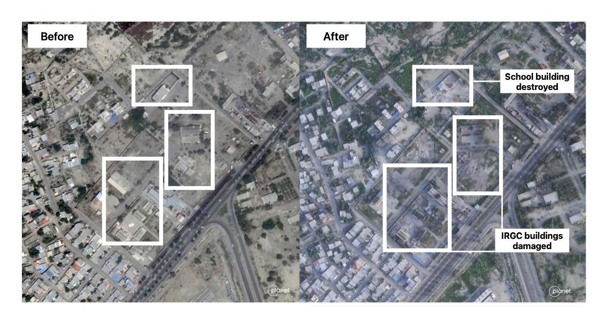
The other large firm often relied on for satellite updates is Vantor, formerly called Maxar, which currently has controls in place on imagery from parts of the Middle East, a spokesperson said.
Those controls can include limiting who can request new images or purchase historical imagery, “over areas where U.S., NATO, and other allied and partner forces are actively operating, as well as over areas that are being actively targeted by adversaries,” the company said. Vantor has restricted images of U.S. bases and other sensitive sites for years.
Vantor said it remained committed to supporting “responsible journalism” by proactively providing imagery of Iran and the Middle East to journalists around the world, while maintaining safeguards.
Both companies have active U.S. government contracts.
Planet said it consulted with both government and external experts, while Vantor stressed that its decisions were not mandated by any government.
In its statement to customers, Planet said it recognized “that timely data is important to your operations” and did not take the decision lightly, while saying it intended “to resume standard service as soon as safety and security conditions permit.”
Satellite companies curb access to Mideast imagery over concern it could be used “by adversarial actors”
#Satellite #companies #curb #access #Mideast #imagery #concern #adversarial #actors